Making the popular hydrogen maps more available
The hydrogen maps from Ocean Hyway Cluster have received a warm welcome from the member companies. Now the cluster is making the maps accessible to anyone curious about zero-emission transport.
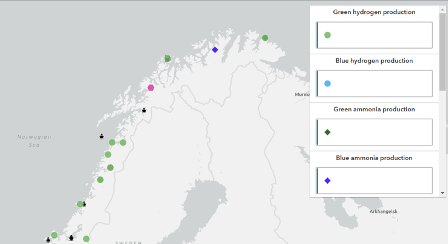
The interactive map “hydrogen infrastructure in Norway” contains an overview of bunkering locations, Norwegian vessels, and production venues sorted by hydrogen fuel.
Through the member's area, members of Ocean Hyway Cluster have access to resources necessary to realise hydrogen in the maritime sector.
Two interactive maps from the member's area, “Hydrogen infrastructure in Norway” and “Global low-carbon vessels”, are now publicly available through a subscription service. The resources have been frequently used by members and give a detailed overview of all ongoing hydrogen infrastructure projects in Norway in addition to a global overview of vessels on low-carbon or zero-emission solutions.
The interactive map “Hydrogen infrastructure in Norway” contains an overview of bunkering locations, Norwegian vessels and production locations sorted by hydrogen-fuel. It also has detailed information on the projects such as involved companies, project phase, expected date for completion, production capacity etc.
Excerpt from the interactive map “Global low-carbon vessels”.
Kristina Skogen from our technical team oversees keeping the database up to speed:
The database is our contribution to realising the value chain on hydrogen in Norway and we see that it is important that this information is available for more than our members in Ocean Hyway Cluster. Collaboration and acceptance are crucial steps to put Norway on the hydrogen map and we hope that the interactive maps contribute to creating new synergies in the market, says Kristina Skogen.
Curious about our interactive maps?
Please contact Kristina Storegjerde Skogen.


